
150 miles of fun
Task force looks to improve river recreation

PERRY BEEMAN Nov 18, 2016 | 12:00 pm
3 min read time
754 wordsBusiness Record Insider, Economic Development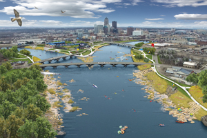
A draft water trails plan developed by the Des Moines Area Metropolitan Planning Organization calls for the removal of downtown dams, easier river accesses in the metro for paddlers, and designated wading and fishing areas.
The report is circulating, as are water trails task force members Rick Tollakson, president and CEO of Hubbell Realty Co., and Teva Dawson, senior planner at the Des Moines Area Metropolitan Planning Organization. They have been filling people in on the plans and laying groundwork for a $500,000 feasibility study next year looking at specific projects costs after the overall plan is approved.
There may still be a debate on priorities, but Dawson said one is clear. “There is almost an expectation that the dams will be mitigated,” meaning removed in favor of a stairstep of whitewater or another solution.
In fact, when the MPO asked area residents what their greatest fear or concerns about local waterways were, many said they feared the dams in downtown Des Moines would not be removed, Dawson said. “Funding is a concern,” she added.
The price tag for that would be one of the questions answered by the engineering studies next year, one that will focus on downtown Des Moines and another on all other areas.
The idea is to make it easier for kayakers and canoe paddlers to use the rivers downtown. It appears unlikely those stretches will ever be deep enough for boating, and the rapids that are likely to take the place of the dams would prevent the bigger craft, too.
Tollakson, who leads the water trails committee, said work after the study is completed could help prevent more deaths at the Center Street dam, which has trapped boaters who accidentally went over and is one of the state’s deadliest dams.
This isn’t just about downtown, though. The study gives detailed views of stretches of river all over the area, with detailed information about amenities. A related website gives an interactive view of what recreationalists will find in various spots, with photos and maps.
Tollakson personally floated Beaver Creek in Johnston, from 70th Avenue to Merle Hay Road, with Johnston Mayor Paula Dierenfeld.
“That little section is gorgeous, and here are some rapids. It’s interesting,” Tollakson said. “All they need to do is figure out access,” other than scrambling up and down steep banks, holding on to weeds for security.
Dawson said the study shows there are experiences for people of all levels, and Beaver Creek is a good example. It would be great for beginners, she said. The downtown Des Moines stretch could be designed with easy routes and some that would challenge experienced paddlers. So would the route downstream to Lake Red Rock. Walnut Creek and Fourmile Creek have potential for outdoor activities, too, Dawson said.
The work on the water trails turned up other potential uses. Colby Park in Windsor Heights is right next to a popular bike path but at this point has no access to Walnut Creek, which also runs nearby. There is talk of finding quiet stretches where wading areas can be designated. In West Des Moines, some want to promote a route designed for a combination of biking and floating on the river.
Tollakson said he will ask cities and businesses to help pay for the feasibility study. MPO was expected to approve the plan this week.
MPO Executive Director Todd Ashby said he hopes the new drive to get people to play in, on and around the river will mean more people will be interested in cleaner waterways.
Not since outdoorsman and now Iowa Department of Natural Resources employee Nate Hoogeveen wrote a statewide guide to kayaking and canoeing in Iowa, “Paddle Iowa,” has there been such a comprehensive look at getting outside. The MPO report, on behalf of the Iowa Department of Natural Resources, guides people to boat ramps, wading areas, fishing spots, bike trails and other niceties along 150 miles of waterways in Central Iowa. The report drew from comments via 23 focus groups, three surveys, seven design workshops, two public meetings about the dams, and three open houses.
The report focuses on key rivers, letting people plan day outings or multiday trips. Planners could see people floating the 31 miles of the Raccoon River in Central Iowa for several days, or 65 miles of the Des Moines River. Or fishing in 15 special areas, wading 18 specially marked zones and using 13 areas altered to make it easier to carry a canoe to the stream.
Trending News