
An area flooded with questions and rumors

.floatimg-left-hort { float:left; } .floatimg-left-caption-hort { float:left; margin-bottom:10px; width:300px; margin-right:10px; clear:left;} .floatimg-left-vert { float:left; margin-top:10px; margin-right:15px; width:200px;} .floatimg-left-caption-vert { float:left; margin-right:10px; margin-bottom:10px; font-size: 12px; width:200px;} .floatimg-right-hort { float:right; margin-top:10px; margin-left:10px; margin-bottom:10px; width: 300px;} .floatimg-right-caption-hort { float:left; margin-right:10px; margin-bottom:10px; width: 300px; font-size: 12px; } .floatimg-right-vert { float:right; margin-top:10px; margin-left:10px; margin-bottom:10px; width: 200px;} .floatimg-right-caption-vert { float:left; margin-right:10px; margin-bottom:10px; width: 200px; font-size: 12px; } .floatimgright-sidebar { float:right; margin-top:10px; margin-left:10px; margin-bottom:10px; width: 200px; border-top-style: double; border-top-color: black; border-bottom-style: double; border-bottom-color: black;} .floatimgright-sidebar p { line-height: 115%; text-indent: 10px; } .floatimgright-sidebar h4 { font-variant:small-caps; } .pullquote { float:right; margin-top:10px; margin-left:10px; margin-bottom:10px; width: 150px; background: url(http://www.dmbusinessdaily.com/DAILY/editorial/extras/closequote.gif) no-repeat bottom right !important ; line-height: 150%; font-size: 125%; border-top: 1px solid; border-bottom: 1px solid;} .floatvidleft { float:left; margin-bottom:10px; width:325px; margin-right:10px; clear:left;} .floatvidright { float:right; margin-bottom:10px; width:325px; margin-right:10px; clear:left;}
Let’s confirm a rumor that circulated after Des Moines River floodwaters exceeded projections last summer and swamped the U.S. Highway 65 bypass east of Des Moines.
The rumor mill is correct. There are no big, boxy concrete culverts under the highway. But culverts by any other name, in this case “concrete pressure equalizers,” apparently are in place and have been since the bypass was completed and opened for traffic in the late 1990s.
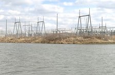
The problem is that culverts or pipes wouldn’t have averted the flooding that caught state and federal highway planners by surprise in June 2008 when the Des Moines River swept over the highway, caused some damage at a MidAmerican Energy Co. substation near Southeast 44th Avenue and Southeast 45th Street and forced primates to higher ground at the nearby Great Ape Trust of Iowa, a state highway engineer said.
And those aren’t the only rumors floating in the backwash of memories related to the flood.
One of those is that MidAmerican suffered major damage to transformers at its substation. Not so, said spokeswoman Ann Thelen. Although the substation did take on water and suffered some damage as a result.In addition, it was suggested that an area north of the substation at a road closed after Highway 65 was completed had been “dammed up’ to prevent future flooding.
Again, not so, Thelen said.
Looking for a cause
The Iowa transportation and natural resources departments, along with the U.S. Army Corps of Engineers, have spent several months analyzing data to determine why the flood exceeded expectations, rising higher in an area west of the highway than during flooding in 1993, prior to construction of Highway 65 and a bridge over the Des Moines River near Vandalia Road.
The Iowa Department of Transportation (DOT) is creating computer models that will crunch the numbers and possibly provide an answer, spokeswoman Dena Gray-Fisher said.
That research has caught the attention of highway planners and other interested parties, some of whom have come up with their own theories as to why flooding was worse last summer than in 1993.
“What has changed since 1993? The obvious change is Highway 65,” said Roger Less, chief of the U.S. Army Corps of Engineers Rock Island District design branch.
His office provided data to the DOT about water flow, the Des Moines River channel and the overall topography of the Red Rock flood plain.
Building the highway required obtaining permits from the Corps of Engineers because the road passes through the flood plain.
Part of that permitting process was the approval of a flood mitigation area south of the Des Moines River near Vandalia Road.
According to a series of letters beginning in 2000, the Corps of Engineers was concerned that the flood mitigation area, a sort of dry pond that fills when the river crests above its banks, was not large enough to handle a flood, particularly if one flood would shortly follow another.
The Corps of Engineers reiterated its concerns two years later, triggering a response from the DOT that “we regret the shortage of flood storage” at the site.
At the time, the Corps of Engineers wanted to be able to contain 315,000 cubic yards of floodwater, the amount that would be displaced by fill dirt used to elevate Highway 65.
In November 2007, the DOT sent a post-construction report to the Corps of Engineers stating that the flood storage area had been enlarged by nearly 43,000 cubic yards to meet Corps of Engineers requirements. Dirt from the excavation site was used as fill during the reconstruction of a section of Interstate 235, according to DOT records.
Pipes, not culverts
More than a decade earlier, the DOT had countered what appears to be a Corps of Engineers requirement to install a box culvert under the highway.
In its permitting process, the DOT proposed using the three concrete pressure equalizers rather than a single culvert, saying that they would achieve the same purpose, mainly to allow drainage from the west side of the highway to the east.
The permit was granted with the requirement that the pipes would be installed.
Less, who was not involved in the permitting process for the highway in the early 1990s, said he did not know whether the presence or lack of culverts was an issue last summer when floodwaters backed up from the highway west toward Great Ape Trust and MidAmerican’s nearby Southeast Polk substation.
“That’s an issue for the DOT to consider,” he said.
Tony Gustafson, assistant manager for DOT District 1, which includes the bypass area, said he doubted that the pipes or culverts could have moved enough water to avoid the flooding.
“Culverts aren’t an issue with the bypass,” he said.
Gustafson, who was not involved in design work for the bypass in the early 1990s, said the pipes probably were substituted for a culvert to save money.
“In the early 1990s, it was probably cheaper to fabricate the pipes off site, bring them to the project and tie them together,” he said.
Awaiting a computer model
The DOT will not complete its computer modeling for a few months, Gustafson said.
Less said the Army Corps of Engineers identified “some deficiencies, I wouldn’t call them major deficiencies” as a result of its initial research into the flooding around Great Ape Trust and the substation.
“We had a little bit of a scare last summer and we’re doing a little bit of preliminary design work to see what some of the advance measures are that we can do in case there is more flooding,” Less said.
One measure might be to increase the height of the Corps of Engineers’ network of levees in the area by a “foot or two,” he said.
As for other corrective measurers, if any, “the DOT has the lead on that,” Less said.
“We need to allow more water to flow through,” he said.
Less also noted that the modeling might find that the flooding was of a freakish nature that could not have been anticipated.
“It might be that everything they did met criteria,” he said. “It’s just that we had a flood of a magnitude that exceeded the regulatory analysis.”
Gustafson would not speculate about what remedial efforts the DOT might make to avoid flooding in the future.
“We don’t want to jump the gun on how grandiose of a plan we might have to do,” he said, pointing out that floodwater resulted in the closure of Highway 65 between Vandalia Road and Army Post Road for a short time last summer.
Gustafson would not say whether that meant that Highway 65 might require a boost in elevation.
Less did have an answer.
“Raising the highway is not the issue,” he said.
Trending News